Type
|
Desktop tile |
|
|---|---|
|
Entity tile |
|
Description
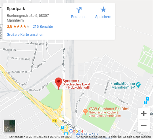
The info tile "My customer card" identifies business partners with markers on a map display. As a prerequisite the addresses have to be geo-coded beforehand.
This tile can only display a single dataset as a marker on a map. The separate info tile My customer card can be configured extended and is suitable for displaying larger quantities of markers. This is only available in connection with the CURSOR Geoanalysis module.
Zooming
The map can be zoomed in with the + icon or zoomed out with -. Zooming is also possible using CTRL +Mouse wheel.
Level selection
The thumbnail view in the lower left corner can be used to switch between satellite and city map level.
Jump to larger view
Via the link Show larger map it is possible to switch to the full view of Google Maps in your own browser tab.
Route planner
If the map is wide enough, a button appears in the detail box
to jump to the route planning. With a click, Google Maps is opened in a separate browser tab and the route from the current (or any) location to the destination is calculated and displayed.
Configuration
Source of the location
|
Use personal data |
Selected The default personal data of the displayed dataset (complete name + address) are automatically determined and used to determine the location. To be used on contact and business partners as well as persons and employees. |
|---|---|
|
Use address
|
Selected Uses the value from the Composite address field as the address for determining the location of the displayed dataset. To be used on addresses and own or custom entities. |
|
Use coordinates |
Selected Uses the values from the Line of Latitude and Line of Longitude fields as coordinates for determining the location of the displayed dataset. To be used on addresses and own or custom entities. |
|
Use own fields |
Selected in the configuration of the tile the desired address fields can be mapped. Configuration:
|
|
Composite address |
Name of the field in which the composed (= complete) address is located, e.g. Required when selecting Use address. |
|
Line of Latitude |
Name of the field in which the value of the line of latitude is located, e.g. Required when selecting Use coordinates. |
|
Line of Longitude |
Name of the field in which the value of the line of longitude is located, e.g. Required when selecting Use coordinates. |
Appearance
|
Initial Zoom |
The zoom level at which the map is started. Possible values in the range from 0 (whole world) to 21 (building details). |
|---|
Map level
|
Traffic/City map |
Selected The map appears in a simplified traffic or city map view. 
|
|---|---|
|
Satellite |
Selected The map appears in a detailed satellite view. 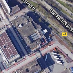
|
Example